

About
The GEO label will be a graphical representation which will comprise 8 informational facets:
|
‘Producer profile’ facet conveys availability of information about the producer of the dataset, e.g., organisation or individual who produced the dataset, their contact information, etc. (ISO191151, FGDC2, GeoViQua PQM3) |
|
‘Lineage information’ facet conveys availability of lineage/provenance information, e.g., processing applied to data and number of process steps. (ISO191151, FGDC2, GeoViQua PQM3) |
|
‘Producer comments’ facet conveys availability of any informal comments about the dataset quality as provided by the dataset producer, e.g., any identified problems, suggested use, etc. (ISO191151, FGDC2, GeoViQua PQM3) |
|
‘Compliance with standards’ facet conveys availability of information about dataset’s compliance with international standards, e.g., compliance with ISO 19115, Dublin Core, etc. (ISO191151, FGDC2, GeoViQua PQM3) |
|
‘Quality information’ facet conveys availability of formal quality measures of the dataset, e.g., uncertainty measures recorded in UncertML, errors, accuracy information, etc. (GeoViQua PQM3) |
|
‘User feedback’ facet conveys availability of feedback, comments and ratings provided by the users of the dataset, e.g., general comments on dataset quality, identified problems, suggested use for the dataset, etc. (GeoViQua UQM4) |
|
‘Expert reviews’ facet conveys availability of domain experts’ comments on dataset quality, e.g., results of formal quality checks, expert suggestions on the dataset applications, etc. (GeoViQua UQM4) |
|
‘Citations information’ facet conveys availability of citations where the dataset was used and cited, e.g., formal reports on dataset quality checks, journal articles, etc. (GeoViQua PQM3, GeoViQua UQM4) |


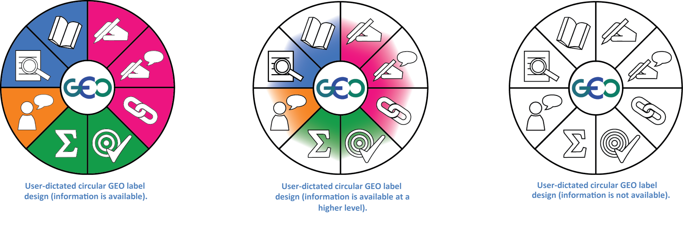
As the GEO label is intended to convey the availability of quality information for a given dataset, each informational facet can represent one of three availability states: ‘available’, ‘not available’, and ‘available only at a higher level’ (indicates that information is not immediately available for the dataset, but is available for a parent dataset). These three information availability states will be expressed through varying the appearance of the facet icons.
|
Fully filled-in background + white icon – indicates that information is available for this dataset. |
|
White background + icon outline – indicates that information is not available for this dataset. |
|
Partially filled-in background + icon outline – indicates that information is available only at a higher level for this dataset. |


Based our user studies, we developed two user-dictated proposals for the GEO label representation.

When integrated in the GEOSS, an individual GEO label will be provided for each dataset in the GEOSS clearinghouse (or other data portals and clearinghouses) based on its available quality information. Producer and feedback metadata documents are being used to dynamically assess information availability and generate the GEO labels. The producer metadata document can either be a standard ISO/FGDC compliant metadata record supplied with the dataset, or an extended version of a GeoViQua-derived metadata record, and is used to assess the availability of a producer profile, lineage, producer comments, compliance with standards, citations and quantitative quality information. GeoViQua is also currently developing a feedback server to collect and encode (as metadata records) user and producer feedback on datasets; these metadata records will be used to assess the availability of user comments and ratings, expert reviews and user-supplied citations for a dataset. The GEO label will provide drill-down functionality which will allow a user to navigate to a GEO label page offering detailed quality information for its associated dataset.
1 ISO19115 compliant producer metadata documents are used to assess availability of information.
2 FGDC complaint producer metadata documents are used to assess availability of information.
3 GeoViQua Producer Quality Model (PQM) complaint producer metadata documents are used to assess availability of information.
4 GeoViQua User Quality Model (UQM) complaint feedback metadata documents are used to assess availability of information.